Industry
The Land Tender platform helps land management collaboratives agree on wildfire reduction plans in just months or years rather than decades.
This technology is a significant advancement in land management, combining cloud-based systems, high-resolution imaging, AI, machine learning, and comprehensive data analysis to facilitate decision-making amongst land stakeholders.
Collaborative members can optimize forest treatment plans to mitigate wildfire risk, without waiting multiple hours for results.
Non-technical and technical users can plan together in an easy-to-understand interactive map.
Land Tender is Vibrant Planet’s foundation for future innovative approaches to natural resource management.
The causes of forest fires are complex and interrelated. Land management collaboratives who work to prevent forest fires understand that it takes the cooperation of a variety of entities - including NGOs, government agencies, tribal governments, local fire districts, and other conservation managers - to manage natural resources and prevent forest fires. However, these collaboratives can take decades to identify solutions and implement plans.
Vibrant Planet saw the opportunity for an innovative product, Land Tender, to help these collaboratives work more efficiently. Analyzing lots of data and creating treatment plans to mitigate forest fires is part of the core work of these groups, but technical and non-technical members of the collaboratives often didn’t have access to the same data. Without shared analysis, collaboratives spent much more time coming to an agreement. Vibrant Planet challenged Presence to build a product from scratch which could offer tools for extensive data analysis and planning, while making it accessible to less technical users.
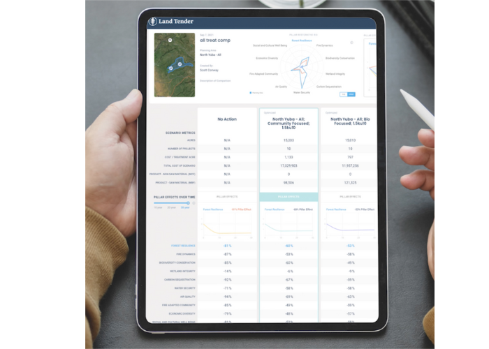
Land Tender leverages GIS and Light Detection and Ranging (LIDAR) data to visualize forest lands nationwide. The Forest Services’ land treatment optimization algorithm, FORSYS, uses this data to offer planning scenarios to users, but it can take hours to analyze data and recommend plans. Presence designed Land Tender’s data model and infrastructure to deliver analysis results in a timeframe that non-technical users would expect, in minutes and not hours.
Technical and non-technical collaborative members expect to be able to easily visualize land treatment scenarios for analysis and comparison. Land Tender gives users the ability to create scenarios on an interactive map and a simple treatment plan interface to compare plans. The interactive map consists of over 70 layers representing land management data, such as natural features, human-created assets, fire danger, drought conditions, and economic potential and risk. Sophisticated but coherent legends help users understand both the individual data points and the map as a whole. Users can tweak scenarios, for example by prioritizing biodiversity or budget, to adapt the plans and see the impact on people, wildlife, the local ecosystem, and more.
When building Land Tender, Presence’s design focused on making the product accessible to all members of land management collaboratives. Empowering users to collaborate on wildfire mitigation helps bring more people to the table to deal with this urgent climate issue. Vibrant Planet plans to use Land Tender as a jumping off point to tackle climate change with a whole range of solutions.
To learn more about Land Tender, please visit Vibrant Planet’s website at https://www.vibrantplanet.net/. To learn how Presence can help your organization, email us at contact@presencepg.com or call 415-970-5770.