
What makes a product innovative? When innovative products make a feature set accessible to many more people, they help us collaborate better and solve complex problems. Building an inclusive user experience is the key to this type of innovation. Recently, Presence had the opportunity to help our client Vibrant Planet build a digital product, Land Tender, that radically changes the process for planning forest treatments to reduce wildfires.
Planning wildfire resilience projects is a team sport. It requires the cooperation of county governments, the U.S. Bureau of Land Management, state conservancies, state land managers and owners, fire districts, nonprofit organizations, and other interested parties across jurisdictions. In the past, the data and planning tools for landscape risk assessment and the design and prioritization of mitigating projects were stuck on foresters’ and scientists’ individual computers. It could take decades for stakeholders to develop solutions together. Meanwhile, each year more and bigger wildfires burned across the arid western United States.
Making a step-change difference in the pace and scale of restoration on public lands meant expanding access to the data and analysis tools. With a focus on making the user experience accessible to more members of wildfire prevention collaboratives, Presence helped Vibrant Planet innovate in this essential field. Leveraging our extensive experience as a digital product development company for some of the most cutting-edge organizations, Presence worked with Vibrant Planet to develop a new digital collaboration tool, Land Tender.
Struggling with a History of Siloed Data
Geographically-based natural resource management collaboratives first developed in response to the rapidly increasing problem of large-scale wildfires. Collaboratives could use GIS data and create a framework for analysis in order to develop one-off resource management plans for their local area. These groups found that the manual process for aligning on data and agreeing to wildfire prevention plans was prolonging their timelines. There was no singular tool that supported the work of these collaboratives by bringing all the information and interested parties together in one place.
Vibrant Planet designed Land Tender to fill this gap. It incorporated specific, value-based GIS data, such as wildlife habitat or community structure layers, and Light Detection and Ranging (LIDAR) data. It then leveraged this information to develop treatment plans based on FORSYS, an algorithm developed by the U.S. Forest Service which optimizes forest treatment plans based on risks and constraints. Land Tender put land management data and analysis into the hands of any given collaborative member.
Building Collaboration through a Digital Product
Vibrant Planet intended to improve how collaborative members work together by offering Land Tender to these groups. Specifically, the product’s goals aimed to (1) “create an easily understood decision support tool,” (2) “provide comprehensive data, AI driven analysis, and intuitive UI to enable shared assessment, prioritization, and treatment options,” (3) and “increase speed and efficiency of project planning, implementation, and post-project monitoring.”
As Joe Flannery, Vibrant Planet Community Relations Lead described, collaboratives had long needed a scalable data and analysis tool. “What I find telling is that people and investors unfamiliar with the space were dumbfounded that a product so obvious and clear didn’t already exist… We built something that is far past due,” he commented. Vibrant Planet challenged Presence to create a product every collaborative member could use easily – without sacrificing analytical and planning capabilities.
Re-shaping user expectations
The Presence team encountered their first technical hurdle when leveraging the U.S. Forest Service’s algorithm to create land treatment plans. While technical users and scientists were accustomed to clunky tools and multi-hour waits for results from FORSYS, the collaboratives’ non-technical users had radically different expectations. If Land Tender’s user experience did not mirror best practices of other software they used, it was unlikely that they would adopt it. Scott Conway, Vibrant Planet’s project team lead for the project reflected on the user experience, stating “many scientists might say ‘that’s not my problem,’ but if they want the tool to be used, it is a problem.”
When Presence’s engineering team initially started feeding GIS data into the FORSYS’ treatment algorithm, it took hours to provide treatment recommendations back to the user. Not willing to settle for the status quo, the engineers went back to the drawing board to redesign the app’s infrastructure. Presence engineers re-architected Land Tender to run the algorithm in what Vibrant Planet called a “cup of coffee time,” the time it takes to get up from your desk and grab a new cup of coffee. Land Tender would best foster collaboration if it offered a product experience that worked for the full spectrum of users.
Designing an inviting UI/UX design
When land management collaboratives shared wildfire prevention-related data and potential solutions through offline methods, conflicts arose because members did not have equal access to the information and treatment plans. Land Tender aimed to democratize this process by making sure everyone could participate in planning.
Not surprisingly, building a collaborative product required a collaborative design process, which was led by Presence designer Natalie Hansen, Presence Project Lead Kevin Rohling, and Vibrant Planet Product Advisor Maria Tran. Design was paramount because Land Tender needed to present such a large amount of data to users which could easily overwhelm and confuse them. Natalie started from scratch working with Vibrant Planet to deeply understand all aspects of their product vision and strategy.
Land Tender’s design was based on an understanding of how users would be working together to prevent wildfires. Natalie learned about the problems the collaboratives were trying to solve, their desires for the product design, and how group members would feel when using Land Tender. Then the combined design team iterated on discovery, prioritization of the minimum viable product, and Figma designs over multi-hour sessions. Scott described the process as “a give-and-take between the feedback on the limitation of design and what a user would experience” and noted that both the technology and the science needed to be nimble and adapt to design challenges. The process helped the team tackle two major obstacles to a seamless user experience: the multi-layered map and a clear presentation of potential treatment plans.
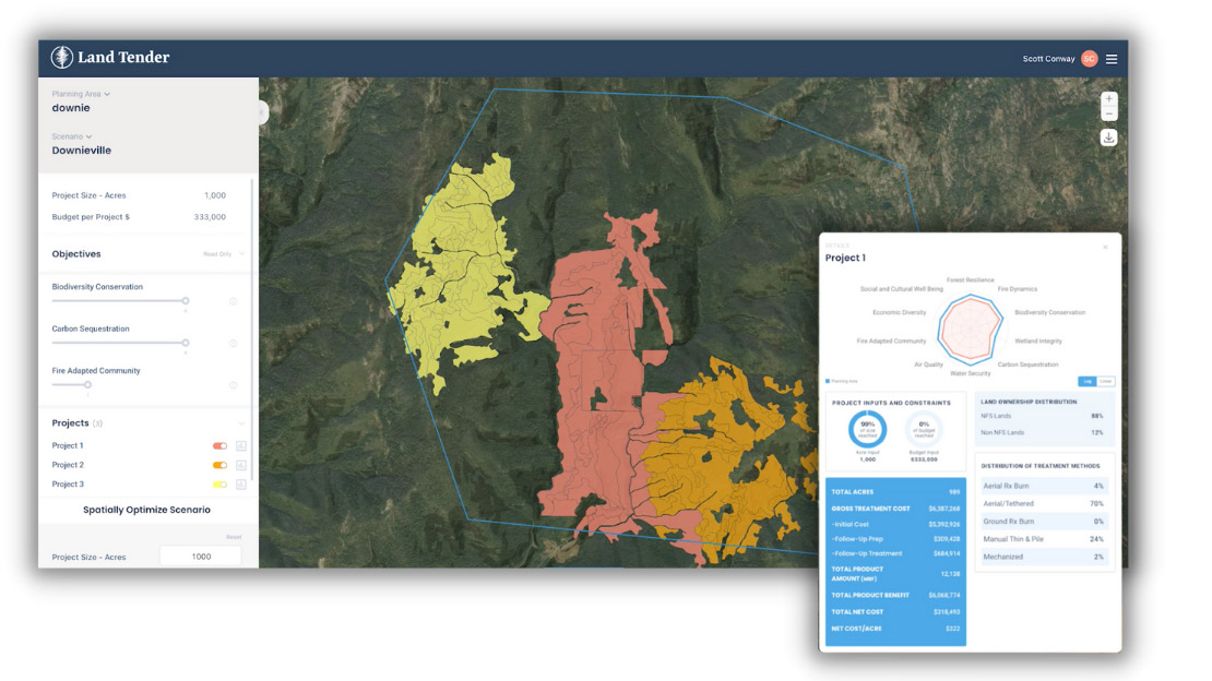
Land Tender needed to present an extremely complex set of data on a map that users could both understand as a whole and as individual data points. “I think the hardest part of this project was the ability to have up to 70 layers on the map working in harmony with one another, so you could understand the dense amount of information in a really easy, at-a-glance view,” Natalie remembered. To accomplish this challenge, Land Tender’s map legend incorporated all the aspects of its land management data, such as natural features, human-created assets, fire danger, drought conditions, and economic potential and risk. It used a complex color palette that indicated the specific aspect and whether that layer was turned on or off. A map legend may have seemed like a minor component compared to the overall map, but Natalie recognized it was crucial to making the maps understandable for all users.
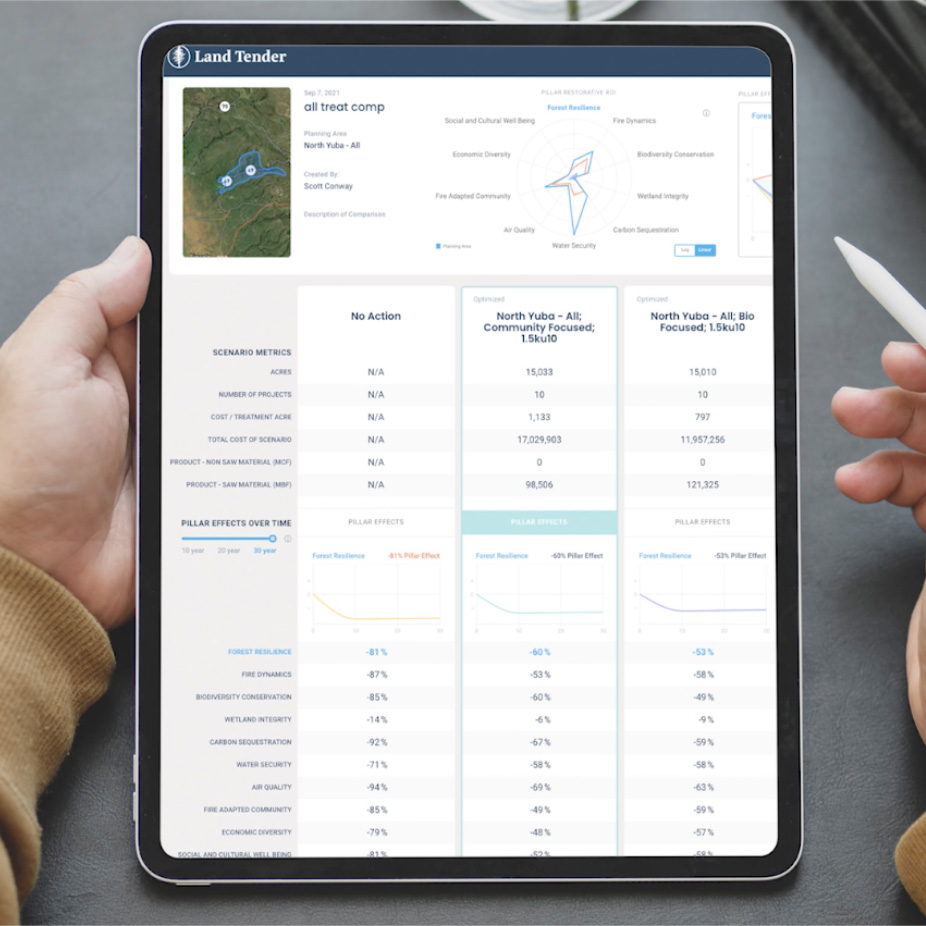
The product’s land treatment comparison tool became one of the features that most delighted users. As Natalie described, “When you review [a treatment plan] in a competitive analysis, you can quickly see the aligned elements. Before that it was just taking forever.” Collaborative members could toggle through different scenarios, including those that prioritize biodiversity and those that prioritize community factors, and look at 10, 20, or 30 year previews of the results of each land treatment. In a simple chart, the comparison tool presented the crucial analysis that all collaborative members need to effectively work together to find solutions for wildfire and land management in their communities. This feature put all the members on equal footing when these groups discussed plans, and helped them avoid one of the major roadblocks to collaboration.
Setting the Stage for Further Innovation
Land Tender is fundamentally changing the experience for collaboratives which plan landscape resilience projects such as wildfire prevention treatments. The Vibrant Planet team sees it just as the first, but necessary, step in changing land management approaches that will lead to many more ways to better manage natural resources.
For example, a large amount of biomass material is often removed when cleaning and thinning out forests for wildfire prevention treatments. This material could itself become a market, but it is not quantifiable at this time. According to Scott, in the future Land Tender will help “develop markets that aren’t there because we have the base information to drive investment in those markets. Currently, no one who is wise would invest in these markets without more information.” The product is setting the stage for much more innovation.
Land Tender is revolutionizing wildfire prevention through its collaborative user experience. In almost any industry, digital products can significantly change the way we work by boosting collaboration and opening up new opportunities, new markets, and new solutions to problems. If you have an idea for a digital product that could help your company or customers by increasing collaboration, Presence can help. Reach out to us today!